|
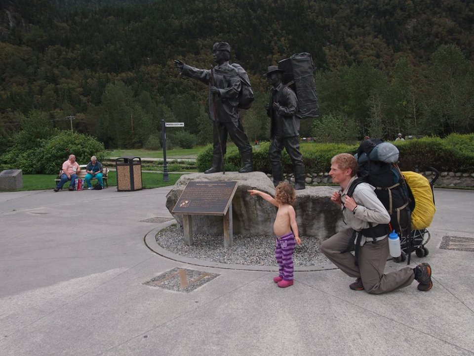
The Chilkoot trail is considered a 53 km long walk-in museum. It was one of major access routes used during the Klondike Gold rush. Between 1896 and 1899 an estimated 22,000 would-be prospectors started up the trail with a years worth of supplies (about 1 ton), prepared to spend a month on the trail and then build a boat to carry them to Dawson. They all hoped to find gold there. Some didn't survive, most of them missed the gold rush and returned home only richer in experiences. On a cloudy morning in August 2016 our little family started up the trail together with a dozen or so other people. We carried just around 55 kg between Christian and I (which included F), and was prepared to spend just 5 days on the trail. We had no hope of finding gold, but hoped to spend some quality family time on the trail. Getting there I felt very relieved as sat in the flight towards Juneau looking down on the beautiful coast mountains. I planned the trip months before, but a week before the trip it was confirmed that I had had another missed miscarriage. It didn't come as a surprise, but it is not recommended to be away from emergency care with an unresolved miscarriage due to the risks of excessive bleeding and infection. I knew that hiking would help me process and accept, so I really wanted to go. Luckily it was confirmed the day before we were scheduled to leave that the miscarriage had happened and there were no further risks. I felt happy and relieved to be on our way. In Juneau we walked to the outdoor store and the grocery store to get the last supplies for our trip. F had difficulty entertaining herself during the grocery shopping, making mental gram/calorie counting quite difficult; it was a challenge, but somehow we managed to purchase the correct amount of food. After acquiring 6 days worth of backcountry packable food, we called a taxi to take us to the campground. The first one showed up with a booster seat instead of the requested cars seat, so we had to call again. We spend the first night at the Auk Village Campground in Juneau. We didn't get to explore much around there as we spend the evening rearranging our packs to fit in the food. The next morning we walked the 3.5km to the ferry that would take us to Skageway. I was very happy that I had last minute had insisted we bring a small stroller for F - not quite like having a car, but it felt almost as useful. We spend a relaxing 6.5 hours on the ferry, enjoying the scenery and reading children books from the small ferry library. It felt like a little time pocket were everything slowed down. After arriving in Skageway we navigated the tourist filled main street to the train station to pick up our return white pass train ticket and the trail office for our permit. Before leaving the trail office we received a half hour orientation on the trail and backcountry etiquette. I wish more places in BC had resources to do stuff like that. After about 1 hour in Skageway we got picket up by Ann Moore, who runs a successful business shuttling hikers the 10 miles to the trailhead in Dyea. We spend the night in the Dyea campground before starting out on our adventure. 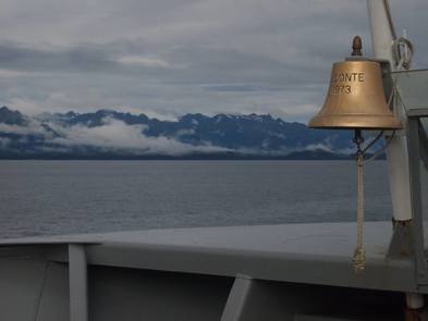 Day 1 Dyea to Canyon City Distance: 13 km Elevation gain: 178 m Elevation loss: 162 m Total hiking time: ~4.5 hours (not including breaks) We had been warned about the trail starting up a step hill, but it was over almost before it started and the rest of the day was mostly flat. This part of the trail felt close to home. The thick rain forest with lots of moss and devil's club encroaching on the trail looked very familiar to south western BC. There were an abnormal number of mushrooms along the trail. Christian constantly wanted to stop and take pictures of them and eventually I had to put my foot down. F enjoyed the mushrooms as well. She would count them as we hiked along. At some point I asked how many she had counted, and she answered 'All of them!' My favourite part of the day was passing through the Beaver Pond. The trail went straight through the pond, and at times I was not quite sure it the board walk was supported or just floating on the pond. We arrived in camp mid-afternoon. The weather was nice so we cooked outside. There was a big mud puddle in the cooking area, so while I was cooking dinner F was busy cooking mud pies. Day 2 Canyon City to Sheep Camp via Canyon City Ruins Distance: 9.5 km Elevation gain: 278 m Elevation loss: 105 m Total hiking time: ~3 hours (not including breaks) We woke up to a nice sunny day and enjoyed a slow morning, since we didn't have much distance to cover. Shortly after setting off from camp we made a turn towards the Canyon City ruins. The suspension bridge over Taiya River was pretty spectacular with a sign warning us to cross just one at a time. I still decided that F and I would cross together. It was very wobbly and kind of scary. The ruins included part of an old tram way, some kind of stove and an old cabin. I am sure there were lots of other things we didn't notice. Christian and I joked that if you just called it a walk in museum, then you can get away with leaving all your junk behind. We stopped for lunch at Pleasant camp. Up until this point F had only walked a few hundred meters by herself, but from Pleasant camp she ran a good distance. She pretended Christian was a skunk and we ran away from him. At Sheep camp I enjoyed the nice sun, while F complained about being too sweaty. The camp was busy and we ended up sharing our dinner table with a nice family from Calgary. 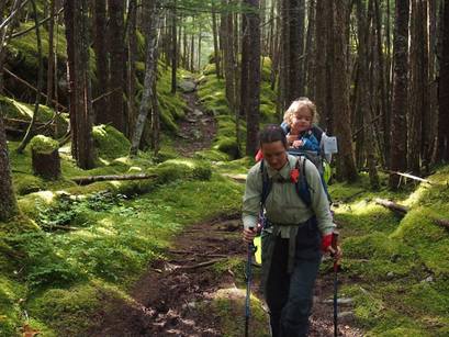 Beautiful moss on the American side. Day 3 Sheep Camp to Happy Camp (summit day) Distance: 12 km Elevation gain: 1061 m Elevation loss: 484 m Total Hiking time: ~5.5 hours (not including breaks) At Sheep Camp the ranger advice you to leave early (6am) on the summit day. We figured a 5 am wake up time would have us on the trail by 7 am, which we deemed plenty early. We actually managed to head off at 6.30am though. It was drizzling and as we gained elevation it also became pretty windy. We took a break before heading into the alpine. F was a bit unsatisfied, but after 45 min of cuddles and snacks, she happily went back in the backpack, where she fell asleep. On the way to the summit we were reminded of the Gold rush days as we passed by shoes, animal bones and a multitude of different rusty objects. We didn't stop until we reached the summit hut around 10.30am. The hut was tiny, but luckily the group of 10 Belgians were a couple of hours behinds us, so we go some nice snack time until they showed up. We covered the rest of the trail to happy camp in a couple of hours. This was definitely the most beautiful part of the trail. The blue alpine lakes surrounded by the green moss and the white lichen was gorgeous. I wished the weather was better so we could stop and truly enjoy the landscape, but the cold wind forced us to keep moving. At happy camp we spend a relaxing afternoon and evening in the hut, while the rain was coming down outside. 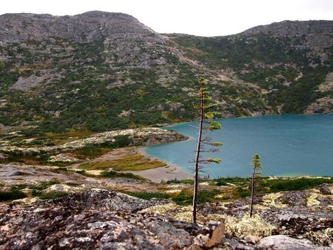 Beautiful lichen and lakes on the Canadian side. Day 4 Happy Camp to Bare Loon Lake Distance: 14 km Elevation gain: 364 m Elevation loss: 522 m Total hiking time: 4.5 hours (not including breaks) The weather was still subpar when we left Happy camp, and F was happy in the backpack all morning, so we decided to just go to Lindeman Lake without any breaks. We enjoy a few mushy blueberries as the alpine changed into boreal forest. An old boat frame reminded us about the long journey the men of the Gold rush still had before them at this point, while we were getting pretty close to our goal. At Lindeman Lake we hid away from the rain all afternoon in a little cabin by the shore. We lit the fire and dried out, while F played with a game of dominos. We also cooked our dinner in the hut as we knew Bare Loon only had a shelter without walls. It was really nice to just have the cabin to ourselves all day, so F could freely play around. It was a gorgeous location right by the lake and it would have been nice to spend a sunny afternoon here. Around 5pm we gather our things and hiked for a couple of hours to Bare Loon Lake. We had a snack in the shelter, threw a few sticks in the lake and set up the tent. The lake was beautiful and Christian was reminded about his childhood in Ontario as the loons called into the night. 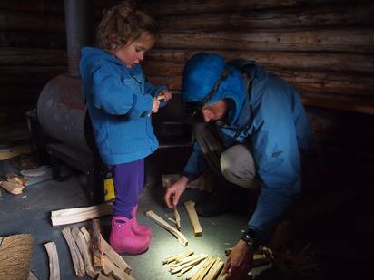 Hiding from the rain at Lindeman. Day 5 Bare Loon to Bennett Distance: 6 km Elevation gain: 159 m Elevation loss: 246 m Total Hiking time: 2 hours We had a leisurely morning before starting the last section to Bennett, and a few parties passed by us before we headed off. The last part of the hike is dry and sandy, which made for heavy feet on a few sections. At Bennett we waited for the train in the campground cabin together with a few other parties. 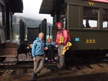 The White pass train finish! Most people hiking the Chilkoot trail seems to have some epic life changing experience, at least that is my impression from reading the log books. I enjoyed the trip a lot, especially spending time with my family. I enjoyed watching the scenery change from rain forest to alpine and boreal forest. I loved all the mushrooms and the beautiful lichen. I liked learning about the Klondike while travelling in the foot steps of all the hopeful young men seeking out a better future. That being said I did not have any life changing epiphanies or anything like that. Although I guess perhaps, during the years of slogging around the mountains, that already happened...
0 Comments
Leave a Reply. |
Recent tripsMarriott Basin
Alcoholic Traverse Tenquille Lake River of Golden Dreams Desolation Sound Eldred Valley Triple M Triathlon - Misty, McBride, Mamquam Recent tips and thoughtBoxy: Our kid hauling bike
Putting skis on a bike Making a low DIN tech binding What is in our backpacks? The bike canoe trailer Making kids crampons Digging a snowcave Make a kid towing harness Categories
All
|

 RSS Feed